Travel time can be defined as the period of time to transverse a route between any two points of interest.
It is a fundamental measure in transportation. Travel time is also one of the most readily understood and
communicated measure indices used by a wide variety of users, including transportation engineers,
planners, and consumers. Travel time data is useful for a wide range of transportation analyses including
congestion management, transportation planning, and traveler information. Congestion management
systems commonly use travel time-based performance measures to evaluate and monitor traffic congestion.
In addition, some metropolitan areas provide real-time travel time prediction as part of their
advanced traveler information systems (ATIS). Travel time data can be obtained through a
number of methods. Some of the methods involve direct measures of travel times along with test
vehicles, license plate matching technique, and ITS probe vehicles. Additionally, various sensors
(e.g. inductance loop detectors, acoustic sensors) in ITS deployment collect a large amount of
traffic data every day, especially in metropolitan areas. Such data can be used for travel time
estimation for extensive applications when direct measurements of travel times are not available
[19].
Travel time, or the time required to traverse a route between any two points of interest, is a
fundamental measure in transportation. Travel time is a simple concept understood and communicated by
a wide variety of applications for transportation engineers and planners. Several data collection techniques
can be used to collect travel times. These techniques are designed to collect travel times and average
speeds on designated roadway segments or links.
Following are the different techniques available for the travel time data collection.
Test Vehicle Techniques
License Plate Matching Techniques
ITS Probe Vehicle Techniques
Emerging and Non-Traditional Techniques
2 Test Vehicle Techniques
Travel time data using active test vehicles in combination with varying levels of instrumentation: manual
(clipboard and stopwatch), an electronic distance measuring instrument (DMI), or a global positioning
system (GPS) receiver. It involves the use of data collection vehicle within which an observer records
cumulative travel time at predefined checkpoints along a travel route. Then this information
converted to travel time, speed, and delay for each segment along the survey route. There are
several different methods for performing this type of data collection, depending upon the
instrumentation used in the vehicle. These vehicles are instrumented and then sent into the field
for travel time data collection, they are sometimes referred to as “active” test vehicles [16].
Advantages
Advanced test vehicle techniques (e.g., DMI or GPS use) result in detailed data.
Low initial cost.
Disadvantages
Sources of possible error from either human or electric sources that require adequate quality
control,
Data storage difficulties.
3 License Plate Matching Techniques
Travel times by matching vehicle license plates between consecutive checkpoints with varying levels of
instrumentation: tape recorders, video cameras, portable computers, or automatic license plate character
recognition [16].
Advantages
Travel times from a large sample of motorists, very simple technique.
Provides a continuum of travel times during the data collection period.
Disadvantages
Travel time data limited to locations where observers or video cameras can be positioned;
Limited geographic coverage on a single day
Accuracy of license plate reading is an issue for manual and portable computer
4 ITS Probe Vehicle Techniques
Travel times using ITS components and passive probe vehicles in the traffic stream equipped with
signpost-based transponders, automatic vehicle identification (AVI) transponders, ground-based radio
navigation, cellular phones, or GPS receivers [16].
Some vehicles are equipped with dynamic route guidance (DRG) device which act as roving traffic
detectors, a non-infrastructure based traffic monitoring system. Such vehicles, which are participating in
the traffic flow and capable of determining experienced traffic conditions and transmitting these to a traffic
center, are called probe vehicles. To determine its position and to register experienced traffic conditions, a
probe vehicle is equipped with on-board electronics, such as a location and a communication device. By
means of the location device, the probe vehicle keeps track of its own geographic position [16].
Through the communication device, the probe vehicle transmits its traffic experiences via a mobile
communication link to a traffic center. For instance, each probe can transmit traffic messages once every
time interval containing its location and its speed at the instant of transmission. In this traffic center the
traffic data received from probe vehicles is gathered, and combined with data from the other monitoring
sources, and processed into relevant traffic information. It is very useful for Advanced Traveler Information
system (ATIS).
Advantages
Low cost per unit of data
Continuous data collection
Automated data collection
Data are in electronic format
No disruption of traffic
Disadvantages
High implementation cost
Fixed infrastructure constraints - Coverage area, including locations of antenna
Requires skilled software
Not recommended for small scale data collection efforts
ITS probe vehicle data collection systems
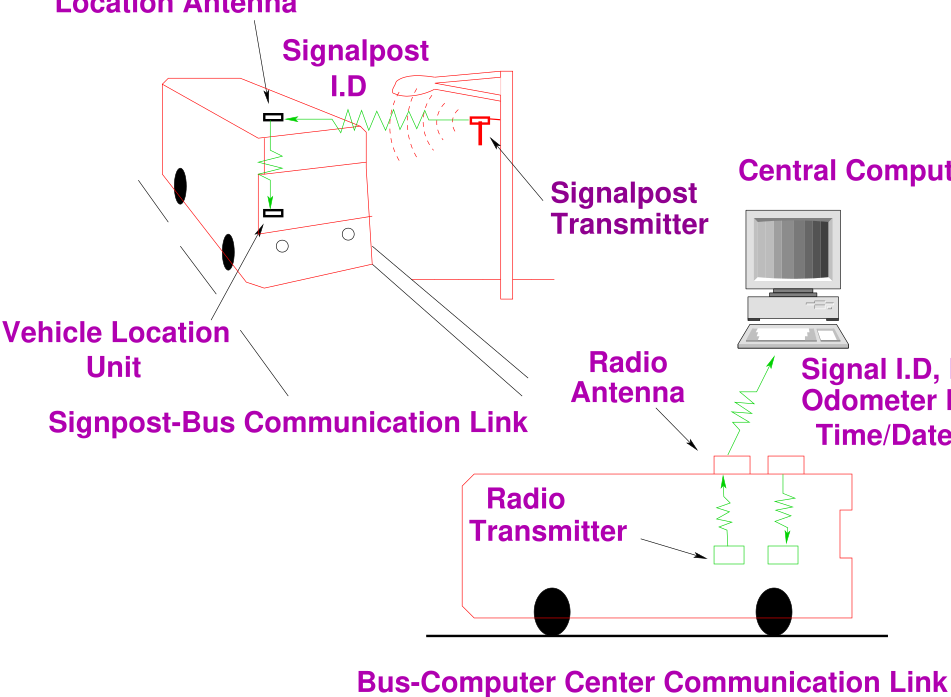
Signpost-Based Automatic Vehicle Location (AVL) - This technique
has mostly been used by transit agencies. Probe vehicles communicate with
transmitters mounted on existing signpost structures shown in Fig. 1 [16].
Figure 1: Signpost-Based AVL Communication Processes, Source: Travel Time Detection Hand
Book, [16]
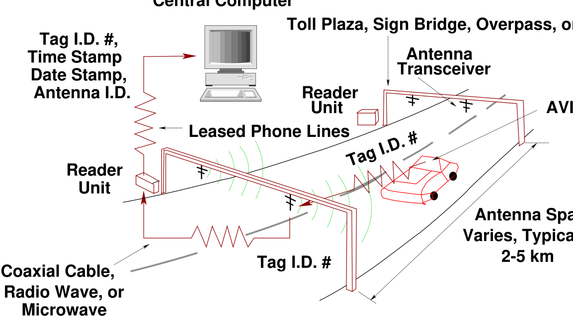
Automatic Vehicle Identification (AVI) - Probe vehicles are equipped with
electronic tags. These tags communicate with roadside transceivers to identify
unique vehicles shown in Fig. 2 and collect travel times between transceivers [16].
Figure 2: AVI Vehicle-to-Roadside Communication Process, Source: Travel Time Detection Hand
Book, [16]
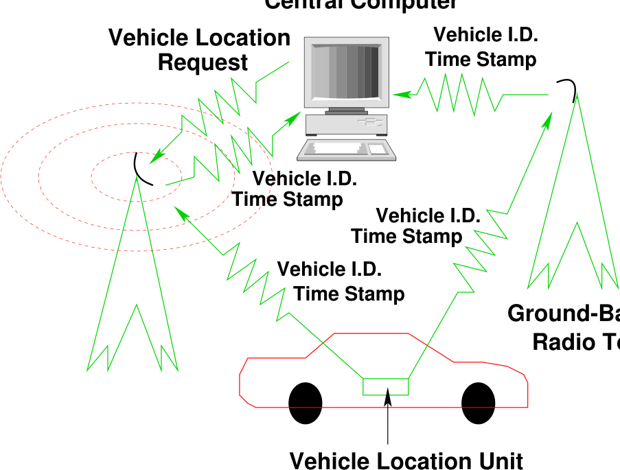
Ground-Based Radio Navigation - It is used for transit or commercial
fleet management, this system is similar to the global positioning
system (GPS). Data are collected by communication between probe
vehicles and a radio tower infrastructure as shown in Fig. 3 [16].
Figure 3: Ground-Based Radio Navigation Communication Process, Source: Travel Time Detection
Hand Book, [16]
5 Cellular Geo-location
This experimental technology can collect travel time data by discretely tracking cellular telephone call
transmissions. Cellular telephones are also useful to collect travel time data. Two techniques have
been applied using cellular technology: cellular telephone reporting and cellular geolocating
[16].
5.1 Cellular Telephone Reporting
An operator at the central control facility records each driver’s identification, location, and time, by
monitoring the time between successive telephone calls, travel time or travel speed between reporting
locations are determined. It is useful for assessment of current traffic conditions and for collecting travel
time data during delays or accidents. The cellular telephone reporting method is recommended for
short-term studies with low accuracy requirements.
5.2 Cellular Geolocation
The cellular geolocating methodology discreetly tracks cellular telephone calls to collect travel time data
and monitor freeway conditions. This technique utilizes an existing cellular telephone network,
vehicle locating devices, and a central control facility to collect travel time data. All vehicles
equipped with cellular telephones are potential probe vehicles. The system automatically detects
cellular telephone call initiations and locates the respective probe vehicle within a few seconds.
Advantages
Driver recruitment not necessary
No in-vehicle equipment to install
Large potential sample
Disadvantages
Low accuracy
Privacy issues
Infrastructure dependent
6 Emerging and Non-Traditional Techniques
Emerging or non-traditional techniques are based on using “point” vehicle detection equipment, such as
inductance loop detectors or video cameras. Travel time estimation algorithms have been developed
based upon measurable point parameters such as volume, lane occupancy, or vehicle headways.
Image matching algorithms are used to match vehicle images or signatures captured at two
consecutive observation points. Following are some of the methods used in emerging techniques
[16].
6.1 Extrapolation Method
Estimates average travel time by spot speeds, applied for short roadway segments between detection
devices. It is more suitable for low accuracy application. The most accurate method to measure vehicle
speed with loop detectors is to place two detectors in series, which is referred to as “speed trap” or “loop
trap”. The accuracy of inductance loop speed traps is dependent upon the trap length, inductance loop
wire type, and consistency in design. Many inductance loop detectors are single loops; primary application
is to collect vehicle counts and lane occupancy. Many research attempts have been made to utilize
speed-flow relationships to estimate vehicle speeds from single loop detectors. The following
1 and 2 equations have been used to estimate spot speeds from single loop detectors [16].
\begin {equation} Spot speed = \frac {volume}{lane occupancy \times g} \label {qeAutoSingleLoopSpotSpeed} \end {equation} where, \( g\) = speed correction factor (based upon assumed vehicle length, detector configuration, and traffic
conditions). \begin {equation} Travel time = \frac {Link Length in km}{Spot speed in \frac {km}{hr}} \times 3600 \frac {sec}{hr} \label {qeAutoTravelTime} \end {equation}
6.2 Vehicle Signature Matching
Calculates travel time by matching unique vehicle signatures between sequential observation points. These
methods can utilize a number of point detectors such as inductance loop detectors, weigh-in motion
sensors, video cameras, and laser scanning detectors. Vehicle signatures between two consecutive locations
to provide a link based travel time and speed. It provides alternative to ITS probe vehicle based on travel
time measurement, in which a probe vehicle is identified and matched between two locations using a
unique identification number.
Vehicle signature matching had been investigated using a number of different point detection
devices, mostly with inductance loop detectors. Several algorithms are available to capture
vehicle signatures from a loop detector frequency detuning curve. Different types and classes of
vehicles provide different types of signatures. The unique features of a vehicle signature are then
compared to signatures within a given time frame at a downstream location. The signature is
matched when a large number of feature correlations have been found within vehicle signatures at
the downstream location. The vehicle signature matching technique does not match every
vehicle signature captured, but potentially match a large enough percentage as to be significant
[16].
7 Summary
Detailed travel time estimation by different techniques has been discussed in this chapter. Also travel time
estimation by vehicle technology and emerging techniques such as vehicle signature have also been
discussed in this chapter.
Exercises
In the absense of any automated equipments, how would you conduct a survey to get travel
time data in a stretch of road.
References
Texas Transportation Institute, Texas A and M University System. Travel Time Data
Collection Handbook,Report FHWA-PL-98-035, 1998.
Traffic Detector Handbook. Third Edition Volume II, Publication No.FHWA-HRT-06-139
October 2006., 2006.
Final Report of Evaluation of Freeway Travel Time Estimates. Castle Rock Consultants Inc,
Portland State University, 2019.
B Coifman. Length based vehicle classification on freeways from single loop Detectors. al
University Transportation Center Final Report, 2009.
G C de Silva. Automation of Traffic Flow Measurement Using Video Images. Thesis Report,
University of Moratuwa, 2001.
S Ding. Freeway Travel Time Estimation using Limited Loop Data. Master Thesis, The
University of Akron, 2008.
M L Y Elena and L A Klein. Summary of vehicle detection and surveillance technologies
used in intelligent transportation systems. FHWA Report, New Mexico State University and
VDC Project Consultant, 2000.
A Faghri and K Hamad. Applications of GPS in Traffic Management. 2002.
L Guillaume. Road Traffic Data: Collection Methods and Applications. JRC Technical note
47967, 2008.
U Leeds. Collection Methods for Additional Data, IMAGINE project no. 503549. Institute
for Transport Studies, University of Leeds, United Kingdom, 2006.
P T Martin, Y Feng, and X Wang. Detector Technology Evaluation. Department of Civil
and Environmental Engineering, Utah Traffic Lab, 2003.
S T Mohammad. Vehicle re-identification Based on Inductance Signature Matching. Master
thesis, University of Toronto, 2011.
N Nihan, X Zhang, and Y Wang. Improved System for Collecting Real-Time Truck Data
from Dual Loop Detectors. Transportation Northwest, 2005.
S G Ritchie S Park and O Cheol. Field Investigation of Advanced Vehicle Re-identification
Techniques and Detector. California PATH Research Report, 2002.
A Parsekar. Blind Deconvolution of Vehicle Inductive Signatures for Travel Time Estimation.
Master thesis, Department of Computer Science, University of Minnesota Duluth, Duluth,
Minnesota -55812, 2004.
C Ulberg. Vehicle occupancy forecasting, Technical Report. Washington State Department of
Transportation Technical, Graduate School of Public Affairs University of Washington Seattle,
Washington 98105, 1994.
J Xia and M Chen. Freeway Travel Time Forecasting Under Incident. Final Report,
Southeastern Transportation Center, Department of Civil Engineering, University of
Kentucky, Lexington, KY 40506, 2007.
B Young and M Saito. Automated Delay Estimation at Signalized Intersections. Research
Division, 2011.
Y Zhirui. Speed estimation using single loop detector outputs. Some studies, Ph.D thesis,
Department of CIVIL Engineering, Texas A and M University, 2007.
Acknowledgments
I wish to thank several of my students and staff of NPTEL for their contribution in this lecture. Specially,
I wish to thank my student K. B. Raghuram for his assistance in developing the lecture note, and my staff
Ms. Reeba in typesetting the materials. I also appreciate your constructive feedback which may be sent to
tvm@civil.iitb.ac.in. Prof. Tom V. Mathew, Department of Civil engineering, Indian Instiute of
Technology Bombay, India.