The geometric design of highways deals with the dimensions and layout of visible features of the highway.
The emphasis of the geometric design is to address the requirement of the driver and the vehicle such as
safety, comfort, efficiency, etc. The features normally considered are the cross section elements, sight
distance consideration, horizontal curvature, gradients, and intersection. The design of these features is to
a great extend influenced by driver behavior and psychology, vehicle characteristics, traffic characteristics
such as speed and volume. Proper geometric design will help in the reduction of accidents and their
severity. Therefore, the objective of geometric design is to provide optimum efficiency in traffic operation
and maximum safety at reasonable cost. The planning cannot be done stage wise in this case like that of a
pavement, but has to be done well in advance. The main components that will be discussed
are:
Factors affecting the geometric design,
Highway alignment, road classification,
Pavement surface characteristics,
Cross-section elements including cross slope, various widths of roads and features in the road
margins.
Sight distance elements including cross slope, various widths and features in the road margins.
Horizontal alignment which includes features like super elevation, transition curve, extra
widening and set back distance.
Vertical alignment and its components like gradient, sight distance and design of length of
curves.
Intersection features like layout, capacity, etc.
2 Factors affecting geometric design
A number of factors affect the geometric design and they are discussed in detail in the following
sections.
2.1 Design speed
Design speed is the single most important factor that affects the geometric design. It directly affects the
sight distance, horizontal curve, and the length of vertical curves. Since the speed of vehicles vary with
driver, terrain etc, a design speed is adopted for all the geometric design.
Design speed is defined as the highest continuous speed at which individual vehicles can travel with
safety on the highway when weather conditions are conducive. Design speed is different from the legal
speed limit which is the speed limit imposed to curb a common tendency of drivers to travel beyond
an accepted safe speed. Design speed is also different from the desired speed which is the
maximum speed at which a driver would travel when unconstrained by either traffic or local
geometry.
Since there are wide variations in the speed adopted by different drivers, and by different types of
vehicles, design speed should be selected such that it satisfy nearly all drivers. At the same time, a higher
design speed has cascading effect in other geometric designs and thereby cost escalation. Therefore, an
85th percentile design speed is normally adopted. This speed is defined as that speed which is
greater than the speed of 85% of drivers. In some countries this is as high as 95 to 98 percentile
speed.
2.2 Topography
The next important factor that affects the geometric design is the topography. It is easier
to construct roads with required standards for a plain terrain. However, for a given design
speed, the construction cost increases multiform with the gradient and the terrain. Therefore,
geometric design standards are different for different terrain to keep the cost of construction
and time of construction under control. This is characterized by sharper curves and steeper
gradients.
2.3 Other factors
In addition to design speed and topography, there are various other factors that affect the geometric
design and they are briefly discussed below:
Vehicle: :The dimensions, weight of the axle and operating characteristics of a vehicle
influence the design aspects such as width of the pavement, radii of the curve, clearances,
parking geometrics etc. A design vehicle which has standard weight, dimensions and operating
characteristics are used to establish highway design controls to accommodate vehicles of a
designated type.
Human: The important human factors that influence geometric design are the physical,
mental and psychological characteristics of the driver and pedestrians like the reaction time.
Traffic: It will be uneconomical to design the road for peak traffic flow. Therefore a reasonable
value of traffic volume is selected as the design hourly volume which is determined from
the various traffic data collected. The geometric design is thus based on this design volume,
capacity etc.
Environmental: Factors like air pollution, noise pollution etc. should be given due
consideration in the geometric design of roads.
Economy: The design adopted should be economical as far as possible. It should match with
the funds alloted for capital cost and maintenance cost.
Others: Geometric design should be such that the aesthetics of the region is not affected.
We will discuss on alignment, classification and factors affecting GD.
3 Road classification
The roads can be classified in many ways. The classification based on speed and accessibility is the most
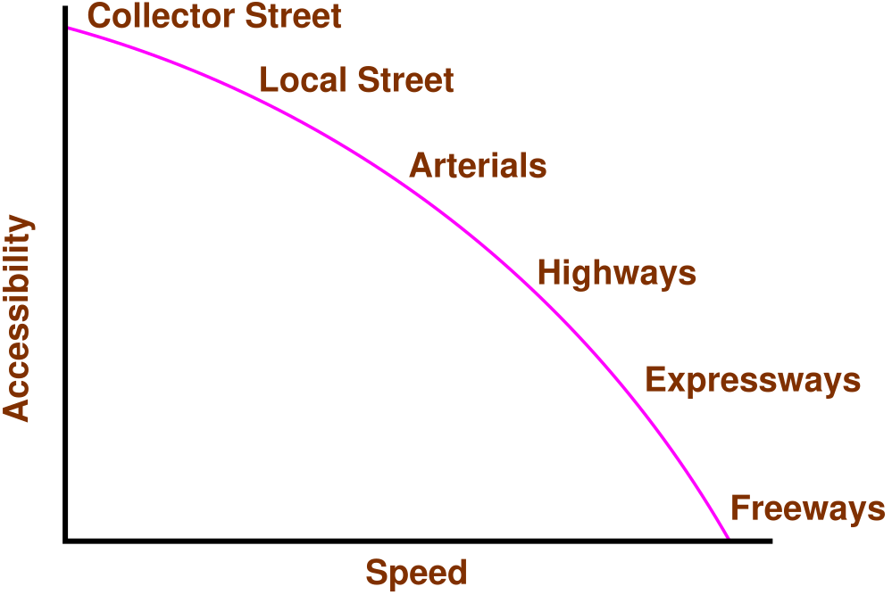
generic one. Note that as the accessibility of road increases, the speed reduces. (See figure 1).
Accordingly, the roads can be classified as follows in the order of increased accessibility and reduced
speeds.
Freeways: Freeways are access-controlled divided highways. Most freeways are four lanes,
two lanes each direction, but many freeways widen to incorporate more lanes as they enter
urban areas. Access is controlled through the use of interchanges, and the type of interchange
depends upon the kind of intersecting road way (rural roads, another freeway etc.)
Expressways: They are superior type of highways and are designed for high speeds ( 120
km/hr is common), high traffic volume and safety. They are generally provided with grade
separations at intersections. Parking, loading and unloading of goods and pedestrian traffic is
not allowed on expressways.
Highways: They represent the superior type of roads in the country. Highways are of two types
- rural highways and urban highways. Rural highways are those passing through rural areas
(villages) and urban highways are those passing through large cities and towns, ie. urban
areas.
Arterials: It is a general term denoting a street primarily meant for through traffic usually on a
continuous route. They are generally divided highways with fully or partially controlled access.
Parking, loading and unloading activities are usually restricted and regulated. Pedestrians are
allowed to cross only at intersections/designated pedestrian crossings.
Local streets : A local street is the one which is primarily intended for access to residence,
business or abutting property. It does not normally carry large volume of traffic and also it
allows unrestricted parking and pedestrian movements.
Collector streets: These are streets intended for collecting and distributing traffic to and from
local streets and also for providing access to arterial streets. Normally full access is provided
on these streets . There are few parking restrictions except during peak hours.
Figure 1: Speed vs accessibility
3.1 Nagpur classification
In Nagpur road classification, all roads were classified into five categories as National highways, State
highways, Major district roads, Other district roads and village roads.
3.1.1 National highways
They are main highways running through the length and breadth of India connecting major
ports , foreign highways, capitals of large states and large industrial and tourist centers
including roads required for strategic movements.
It was recommended by Jayakar committee that the National highways should be the frame
on which the entire road communication should be based.
All the national highways are assigned the respective numbers.
For e.g. the highway connecting Delhi-Ambala-Amritsar is denoted as NH-1 (Delhi-Amritsar),
where as a bifurcation of this highway beyond Fullundar to Srinagar and Uri is denoted as
NH-1_A.
They are constructed and maintained by CPWD.
The total length of National highway in the country is 58,112 Kms, and constitute about 2%
of total road networks of India and carry 40% of total traffic.
3.1.2 State highways
They are the arterial roads of a state, connecting up with the national highways of adjacent
states, district head quarters and important cities within the state
They also serve as main arteries to and from district roads.
Total length of all SH in the country is 1,37,119 Kms.
3.1.3 Major district roads
Important roads with in a district serving areas of production and markets , connecting those
with each other or with the major highways.
India has a total of 4,70,000 kms of MDR.
3.1.4 Other district roads
Roads serving rural areas of production and providing them with outlet to market centers or
other important roads like MDR or SH.
3.1.5 Village roads
They are roads connecting villages or group of villages with each other or to the nearest road
of a higher category like ODR or MDR.
India has 26,50,000 kms of ODR+VR out of the total 33,15,231 kms of all type of roads.
3.2 Modern-Lucknow classification
The roads in the country were classified into 3 classes:
3.2.1 Primary roads
Expressways
National highways
3.2.2 Secondary roads
State highways
Major district roads
3.2.3 Tertiary roads
Other district roads
Village roads
3.3 Roads classification criteria
Apart from the classification given by the different plans, roads were also classified based on some other
criteria. They are given in detail below.
3.3.1 Based on usage
This classification is based on whether the roads can be used during different seasons of the
year.
All-weather roads: Those roads which are negotiable during all weathers, except at major
river crossings where interruption of traffic is permissible up to a certain extent are called all
weather roads.
Fair-weather roads: Roads which are negotiable only during fair weather are called fair weather
roads.
3.3.2 Based on carriage way
This classification is based on the type of the carriage way or the road pavement.
Paved roads with hards surface : If they are provided with a hard pavement course such roads
are called paved roads.(eg: stones, Water bound macadam (WBM), Bituminous macadam
(BM), concrete roads)
Unpaved roads: Roads which are not provided with a hard course of atleast a WBM layer
they is called unpaved roads. Thus earth and gravel roads come under this category.
3.3.3 Based on pavement surface
Based on the type of pavement surfacing provided, they are classified as surfaced and unsurfaced
roads.
Surfaced roads (BM, concrete): Roads which are provided with a bituminous or cement
concreting surface are called surfaced roads.
Unsurfaced roads (soil/gravel): Roads which are not provided with a bituminous or cement
concreting surface are called unsurfaced roads.
3.3.4 Other criteria
Roads may also be classified based on the traffic volume in that road, load transported through that road,
or location and function of that road.
Traffic volume : Based on the traffic volume, they are classified as heavy, medium and light
traffic roads. These terms are relative and so the limits under each class may be expressed as
vehicles per day.
Load transported : Based on the load carried by these roads, they can be classified as class I,
class II, etc. or class A, class B etc. and the limits may be expressed as tonnes per day.
Location and function : The classification based on location and function should be a more
acceptable classification since they may be defined clearly. Classification of roads by Nagpur
Road plan is based on the location and function which we had seen earlier.
4 Highway alignment
Once the necessity of the highway is assessed, the next process is deciding the alignment. The highway
alignment can be either horizontal or vertical and they are described in detail in the following
sections.
4.1 Alignment
The position or the layout of the central line of the highway on the ground is called the alignment.
Horizontal alignment includes straight and curved paths. Vertical alignment includes level and gradients.
Alignment decision is important because a bad alignment will enhance the construction, maintenance
and vehicle operating costs. Once an alignment is fixed and constructed, it is not easy to
change it due to increase in cost of adjoining land and construction of costly structures by the
roadside.
4.2 Requirements
The requirements of an ideal alignment are
The alignment between two terminal stations should be short and as far as possible be straight,
but due to some practical considerations deviations may be needed.
The alignment should be easy to construct and maintain. It should be easy for the operation
of vehicles. So to the maximum extend easy gradients and curves should be provided.
It should be safe both from the construction and operating point of view especially at slopes,
embankments, and cutting. It should have safe geometric features.
The alignment should be economical and it can be considered so only when the initial cost,
maintenance cost, and operating cost are minimum.
4.3 Factors controlling alignment
We have seen the requirements of an alignment. But it is not always possible to satisfy all these
requirements. Hence we have to make a judicial choice considering all the factors.
The various factors that control the alignment are as follows:
Obligatory points: These are the control points governing the highway alignment. These points are
classified into two categories. Points through which it should pass and points through which it
should not pass. Some of the examples are:
bridge site: The bridge can be located only where the river has straight and permanent
path and also where the abutment and pier can be strongly founded. The road approach
to the bridge should not be curved and skew crossing should be avoided as possible. Thus
to locate a bridge the highway alignment may be changed.
mountain: While the alignment passes through a mountain, the various alternatives are
to either construct a tunnel or to go round the hills. The suitability of the alternative
depends on factors like topography, site conditions and construction and operation cost.
intermediate town: The alignment may be slightly deviated to connect an intermediate
town or village nearby.
These were some of the obligatory points through which the alignment should pass. Coming to
the second category, that is the points through which the alignment should not pass
are:
religious places: These have been protected by the law from being acquired for any
purpose. Therefore, these points should be avoided while aligning.
very costly structures: Acquiring such structures means heavy compensation which would
result in an increase in initial cost. So the alignment may be deviated not to pass through
that point.
lakes/ponds etc: The presence of a lake or pond on the alignment path would also
necessitate deviation of the alignment.
Traffic: The alignment should suit the traffic requirements. Based on the origin-destination data of
the area, the desire lines should be drawn. The new alignment should be drawn keeping in view the
desire lines, traffic flow pattern etc.
Geometric design: Geometric design factors such as gradient, radius of curve, sight distance etc. also
govern the alignment of the highway. To keep the radius of curve minimum, it may be required to
change the alignment. The alignments should be finalized such that the obstructions
to visibility do not restrict the minimum requirements of sight distance. The design
standards vary with the class of road and the terrain and accordingly the highway should be
aligned.
Economy:The alignment finalised should be economical. All the three costs i.e. construction,
maintenance, and operating cost should be minimum. The construction cost can be decreased much
if it is possible to maintain a balance between cutting and filling. Also try to avoid very high
embankments and very deep cuttings as the construction cost will be very higher in these
cases.
Other considerations : various other factors that govern the alignment are drainage considerations,
political factors and monotony.
Drainage:
Political: If a foreign territory comes across a straight alignment, we will have to deviate
the alignment around the foreign land.
Monotony: For a flat terrain it is possible to provide a straight alignment, but it will be
monotonous for driving. Hence a slight bend may be provided after a few kilometres of
straight road to keep the driver alert by breaking the monotony.
Hydrological (rainfall/water table):The pavement should be as high above the water
table as possible, so that saturation/submergence and subsequent damge to subgrade
are avoided.
4.4 Special consideration for hilly areas
Alignment through hilly areas is slightly different from aligning through a flat terrain. For the purpose of
efficient and safe operation of vehicles through a hilly terrain special care should be taken while aligning
the highway. Some of the special considerations for highway alignment through a hilly terrain is discussed
below.
Stability of the slopes: for hilly areas, the road should be aligned through the side of the hill
that is stable. The common problem with hilly areas is that of landslides. Excessive cutting
and filling for road constructions give way to steepening of slopes which in turn will affect the
stability.
Hill side drainage: Adequate drainage facility should be provided across the road. Attempts
should be made to align the roads in such a way where the number of cross drainage structures
required are minimum. This will reduce the construction cost.
Special geometric standards: The geometric standards followed in hilly areas are different from
those in flat terrain. The alignment chosen should enable the ruling gradient to be attained in
minimum of the length, minimizing steep gradient, hairpin bends and needless rise and fall.
Ineffective rise and fall : Efforts should be made to keep the ineffective rise and excessive fall
minimum.
5 Summary
This lecture covers a brief history of highway engineering, highlighting the developments of road
construction. Significant among them are Roman, French, and British roads. British road construction
practice developed by Macadam is the most scientific and the present day roads follows this pattern. The
highway development and classification of Indian roads are also discussed. The major classes of roads
include National Highway, State highway, District roads, and Village roads. Finally, issues in highway
alignment are discussed.
References
L R Kadiyali. Traffic Engineering and Transportation Planning. Khanna Publishers, New
Delhi, 1987.
S K Khanna and C E G Justo. Highway Engineering. Nemchand Bros.,, Roorkee, 1991.
William R McShane, Roger P Roess, and Elena S Prassas. Traffic Engineering.
Prentice-Hall, Inc, Upper Saddle River, New Jesery, 1998.
C. S Papacostas. Fundamentals of Transportation Engineering. Prentice-Hall, New Delhi,
1987.
Acknowledgments
I wish to thank several of my students and staff of NPTEL for their contribution in this lecture. I
also appreciate your constructive feedback which may be sent to tvm@civil.iitb.ac.in. Prof.
Tom V. Mathew, Department of Civil engineering, Indian Instiute of Technology Bombay,
India.