Figure 1: ITS user services
Intelligent Transportation Systems (ITS) is the application of computer, electronics, and communication technologies and management strategies in an integrated manner to provide traveler information to increase the safety and efficiency of the road transportation systems. This paper mainly describes ITS user services, ITS architecture and ITS planning. The various user services offered by ITS have been divided in eight groups have been briefly described. The ITS architecture which provides a common framework for planning, defining, and integrating intelligent transportation systems is briefly described emphasizing logical and physical architecture. Integration of ITS in transportation planning process which follows a systems engineering approach to develop a transportation plan is also briefly described in this paper.
Intelligent Transportation Systems (ITS) is the application of computer, electronics, and communication technologies and management strategies in an integrated manner to provide traveler information to increase the safety and efficiency of the surface transportation systems. These systems involve vehicles, drivers, passengers, road operators, and managers all interacting with each other and the environment, and linking with the complex infrastructure systems to improve the safety and capacity of road systems.
As reported by Commission for Global Road Safety(June 2006) , the global road deaths were between 750,000 to 880,000 in the year 1999 and estimated about 1.25 million deaths per year and the toll is increasing further. World health organization report (1999), showed that in the year 1990 road accidents as a cause of death or disability were the ninth most significant cause of death or disability and predicted that by 2020 this will move to sixth place. Without significant changes to the road transport systems these dreadful figures are likely to increase significantly. Traditional driver training, infrastructure and safety improvements, may contribute to certain extent to reduce the number of accidents but not enough to combat this menace. Intelligent Transport Systems are the best solution to the problem. Safety is one of the principal driving forces behind the evolution, development, standardization, and implementation of ITS systems.
ITS improves transportation safety and mobility and enhances global connectivity by means of productivity improvements achieved through the integration of advanced communications technologies into the transportation infrastructure and in vehicles. Intelligent transportation systems encompass a broad range of wireless and wire line communication based information and electronics technologies to better manage traffic and maximize the utilization of the existing transportation infrastructure. It improves driving experience, safety and capacity of road systems, reduces risks in transportation, relieves traffic congestion, improves transportation efficiency and reduces pollution.
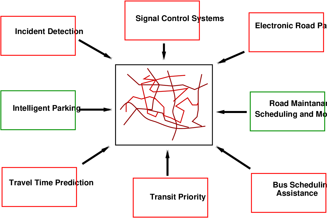
In order to deploy ITS, a framework is developed highlighting various services the ITS can offer to the users. A list of 33 user services has been provided in the National ITS Program Plan. The number of user services, keep changing over time when a new service is added. All the above services are divided in eight groups. The division of these services is based on the perspective of the organization and sharing of common technical functions. Some of the user services offered by ITS are shown in Fig. 1. The eight groups are described as follows:
The main objective of this group of services is to use real time information on the status of the transportation system to improve its efficiency and productivity and to mitigate the adverse environmental impacts of the system. This group of user service is further divided in 10 user services. Most of these services share information with one another in a highly integrated manner for the overall benefit of the road transportation system. These services are described as below:
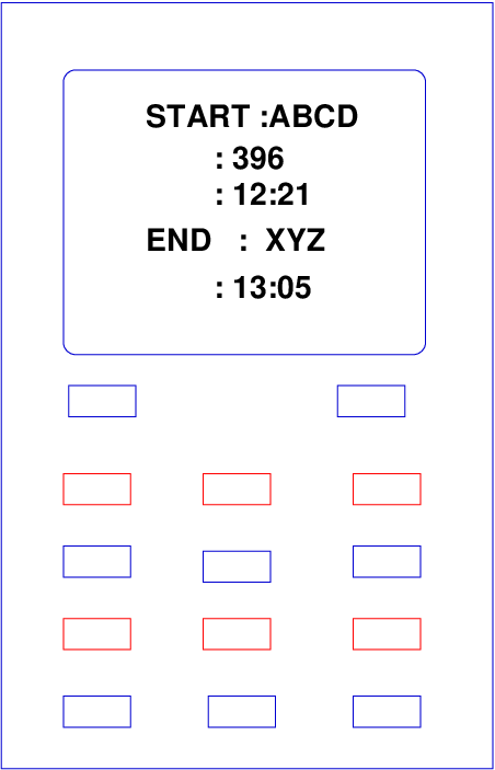
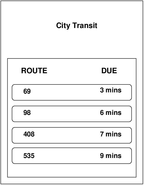
This user service provides information to the travelers about the transportation system before they begin their trips so that they can make more informed decisions regarding their time of departure, the mode to use and route to take to their destinations. The travelers can access this information through computer or telephone systems at home or work and at major public places. Pre travel information can be accessed through mobile phones as shown in Fig. 2. Different routes and respective travel time durations indicated on VMS are shown in Fig. 3. The information include real time flow condition, real incidents and suggested alternate routes, scheduled road construction and maintenance tasks, transit routes, schedules, fares, transfers, and parking facilities.
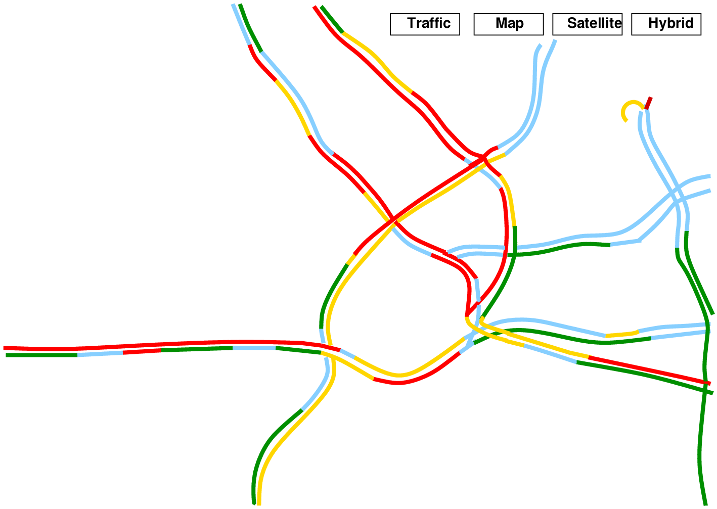
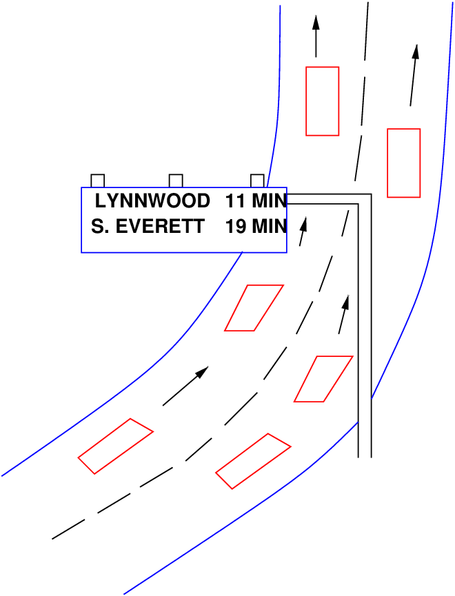
This user service provides travel related information to the travelers en route after they start their trips through variable message signs (VMS), car radio, or portable communication devices. Fig. 4 shows the various congested and non congested routes shown on display screen. VMS indicating different routes and travel time is shown in Fig. 5. This helps the travelers to better utilize the existing facility by changing routes etc to avoid congestion. This also provides warning messages for roadway signs such as stop signs, sharp curves, reduced speed advisories, wet road condition flashed with in vehicle displays to the travelers to improve the safety of operating a vehicle. The information can be presented as voice output also.
This service provides information to the travellers with a suggested route to reach a specified destination, along with simple instructions on upcoming turns and other manoeuvres. This also provides travellers of all modes the real-time information about the transportation system, including traffic conditions, road closures, and the status and schedule of transit systems. The benefits of this service are reduced delay and drivers stress levels particularly in an unfamiliar area.
This user service provide real-time ride matching information to travellers in their homes, offices or other locations, and assists transportation providers with vehicle assignments and scheduling. Travellers give information to the service center and get number of ride sharing options from which they can choose the best.
This service provides a business directory of information on travel-related services and facilities like the location, operating hours, and availability of food, lodging, parking, auto repair, hospitals, gas stations and police facilities. This also makes reservations for many of these traveler services. The traveler services information are accessible in the home, office or other public locations to help plan trips. These services are available en-route also.
This service collects the real time data from the transportation system, processes it into usable information, and uses it to determine the optimum assignment of right-of-way to vehicles and pedestrians. This helps in improving the flow of traffic by giving preference to transit and other high occupancy vehicles or by adjusting the signal timing to current traffic conditions. The information collected by the Traffic Control service is also disseminated for use by many other user services.
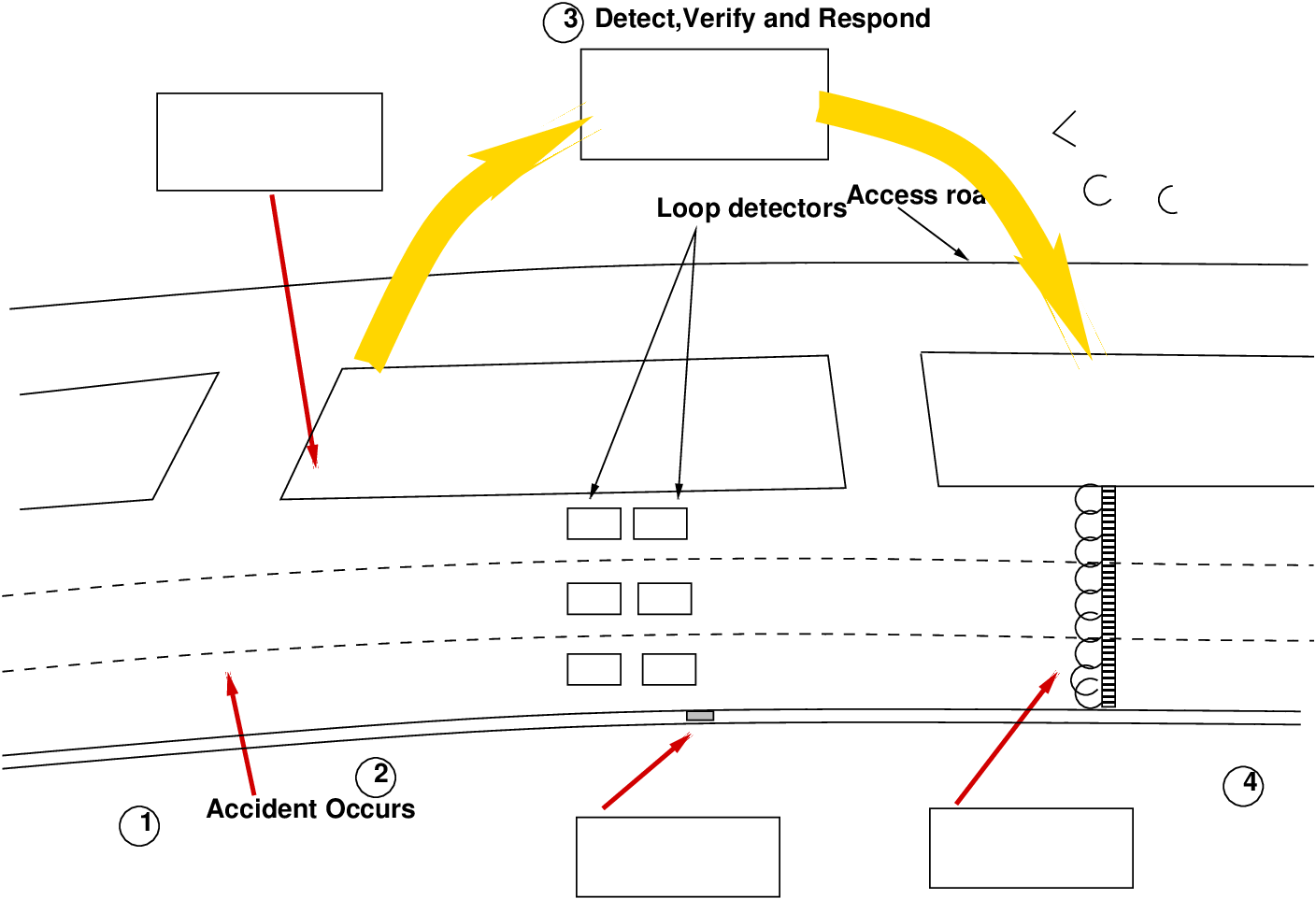
This service aims to improve the incident management and response capabilities of transportation and public safety officials, the towing and recovery industry, and others involved in incident response. Advanced sensors (close circuit TV cameras), data processors and communication technologies are used to identify incidents quickly and accurately and to implement response which minimizes traffic congestion and the effects of these incidents on the environment and the movement of people and goods. Fig. 6 shows the occurrence of incident and its detection by the center and decision implemented responding to the incident on a highway pertaining to incident management.
This user service develop and implement strategies to reduce the number of single occupancy vehicles while encouraging the use of high occupancy vehicles and the use of more efficient travel mode. The strategies adopted are:
The main objective of this service is to monitor and implement strategies to divert traffic away from sensitive air quality areas, or control access to such areas using advanced sensors. This also used to identify vehicles emitting pollutants exceeding the standard values and to inform drivers to enable them to take corrective action. This helps in facilitating implementation and evaluation of various pollution control strategies by authorities.
This service is to provide improved control of highway and train traffic to avoid or decrease the severity of collisions between trains and vehicles at highway-rail intersections. This also monitors the condition of various HRI equipments.
This group of service is concerned with improving the public transportation systems and encouraging their use. Fig. 7 shows different public transportation facilities. This group is divided in four services which are described as below:
This user service collects data through advanced communications and information systems to improve the operations of vehicles and facilities and to automate the planning and management functions of public transit systems. This offers three tasks:
This service is intended to provide information on expected arrival times of t vehicles, transfers, and connections to travellers after they begin their trips using public transportation. This also provide real-time, accurate transit service information on-board the vehicle, at transit stations and bus stops to assist travellers in making decisions and modify their trips underway.
The aim of this service is to offer public transport facility to travellers by assigning or scheduling vehicles by
Under this service, travellers provide information of their trip origin and destination to service station. The center then assigns the closest vehicle to service the request and to inform the travellers regarding arrival of such vehicles well in advance to reduce their anxiety.
This user service creates a secure environment for public transportation operators and support staff and monitors the environment in transit facilities, transit stations, parking lots, bus stops and on-board transit vehicles and generates alarms (either automatically or manually) when necessary. It also provides security to the systems that monitor key infrastructure of transit (rail track, bridges, tunnels, bus guide ways, etc.).
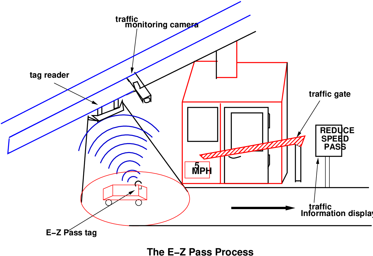
This user service allows travellers to pay for transportation services with a common electronic payment medium for different transportation modes and functions. Toll collection, transit fare payment, and parking payment are linked through a multi-modal multi-use electronic system. With an integrated payment system a traveller driving on a toll road, using parking lot would be able to use the same electronic device to pay toll, parking price and the transit fare. Fig. 8 shows the electronic payment facility by radio car tag.
The aim is to improve the efficiency and safety of commercial vehicle operations. This involves following services:
This service allows enforcement personnel to electronically check safety status, vehicle’s credentials, and size and weight data for the commercial vehicles before they reach an inspection site. The authorities send the illegal or potentially unsafe vehicles only for inspection and bypass safe and legal carriers to travel without stopping for compliance checks at weigh stations and other inspection sites.
At inspection station the safety requirements are checked more quickly and more accurately during a safety inspection using automated inspection capabilities. Advanced equipments are used to check brake, steering and suspension performance and also the driver’s performance pertaining to driver alertness and fitness for duty.
This service monitors the driver, vehicle, and cargo and notify the driver, carrier, and, also to the enforcement personnel, if an unsafe situation arises during operation of the vehicle. This is user service also assures freight container, trailer, and commercial vehicle integrity by monitoring on-board sensors for a breach or tamper event.
This service allows carriers to purchase credentials such as fuel use taxes, trip permits, overweight permit, or hazardous material permits automatically. The mileage and fuel reporting and auditing components are provided to the carriers automatically which reduce significant amount of time and paperwork.
This user service provides immediate information regarding the types and quantities of hazardous materials present at incident location to the emergency personnel in order to facilitate a quick and appropriate response. The emergency personnel are informed regarding shipment of any sensitive hazardous materials so that timely action could be taken in case of accidents.
This service provides information to the drivers, dispatchers, and inter-modal transportation providers, enabling carriers to take advantage of real-time traffic information, as well as vehicle and load location information, to increase productivity.
This user service aims to improve the safety of the transportation system by supplementing drivers’ abilities to maintain vigilance and control of the vehicle by enhancing the crash avoidance capabilities of vehicles. Following user services are included in this group:
This user service provides assistance to vehicle operators in avoiding longitudinal collisions to the front and/or rear of the vehicle. This is achieved by implementing rear-end collision warning and control, Adaptive Cruise Control (ACC), head-on collision warning and control, and backing collision warning to the drivers.
This helps drivers in avoiding accidents that result when a vehicle leaves its own lane of travel, by warning drivers and by assuming temporary control of the vehicle. This service provides to the drivers the lane change/blind spot situation display, collision warning control and lane departure warning and control.
This user service is specifically aimed at providing vehicle operators with assistance in avoiding collisions at intersections. The system tracks the position of vehicles within the intersection area through the use of vehicle-to-vehicle communications or vehicle to infrastructure communications.
This service helps in reducing the number of vehicle crashes that occur during periods of poor visibility by in vehicle sensors capable of capturing an image of driving environment and providing a graphical display of the image to the drivers.
This helps to provide drivers with warnings regarding their own driving performance, the condition of the vehicle, and the condition of the roadway as sensed from the vehicle.
This service helps in reducing the number and severity of injuries caused by vehicle collisions by anticipating an imminent collision and by activating passenger safety systems prior to the actual impact.
This service provides a fully automated vehicle-highway system in which instrumented vehicles operate on instrumented roadways without operator intervention.
This service has two functions:
This service is aimed to provide the functionality needed to store and archive the huge amounts of data being collected on a continuous basis by different ITS technologies.
This user service is aimed to provide the functionality needed for managing the fleets of maintenance vehicles, managing the roadway with regards to construction and maintenance and safe roadway operations.
The ITS Architecture provides a common framework for planning, defining, and integrating intelligent transportation systems. It specifies how the different ITS components would interact with each other to help solving transportation problems. It provides the transportation professionals to address their needs with wide variety of options. It identifies and describes various functions and assigns responsibilities to various stake-holders of ITS. The ITS architecture should be common and of specified standards throughout the state or region so that it can address solution to several problems while interacting with various agencies.
This is developed by US Department of Transportation to provide guidance and co-ordinate all regions in deploying ITS. It documents all information available and keep updating continuously. The national architecture contains the following components:
A number of functions are needed to accomplish the user services. These functional statements are called user services requirements. For all the user services the requirements have been specified. If any new function is added, new requirements are to be defined. Table. 1 shows an illustration of user service requirements for traffic control user service.
| Traffic Control provides the capability to efficiently manage the movement of traffic |
| on streets and highways. Four functions are provided which are |
| (1) Traffic Flow Optimization, |
| (2) Traffic Surveillance, |
| (3) Control, and |
| (4) Provide Information. |
| This will also include control of network signal systems with integration of freeway |
| control. The specified User service requirements |
| (1) TC shall include a Traffic Flow Optimization function to provide the capability |
| to optimize traffic flow. |
| (1.1) Traffic Flow Optimization shall employ control strategies that seek to maximize |
| traffic-movement efficiency. |
| (1.2) Traffic Flow Optimization shall include a wide area optimization capability, to |
| include several jurisdictions. |
| (1.2.1) Wide area optimization shall integrate the control of network signal systems |
| with the control of freeways. |
| (1.2.2) Wide area optimization shall include features that provide preferential |
| treatment for transit vehicles. |
| (2) TC shall include a Traffic Surveillance function. |
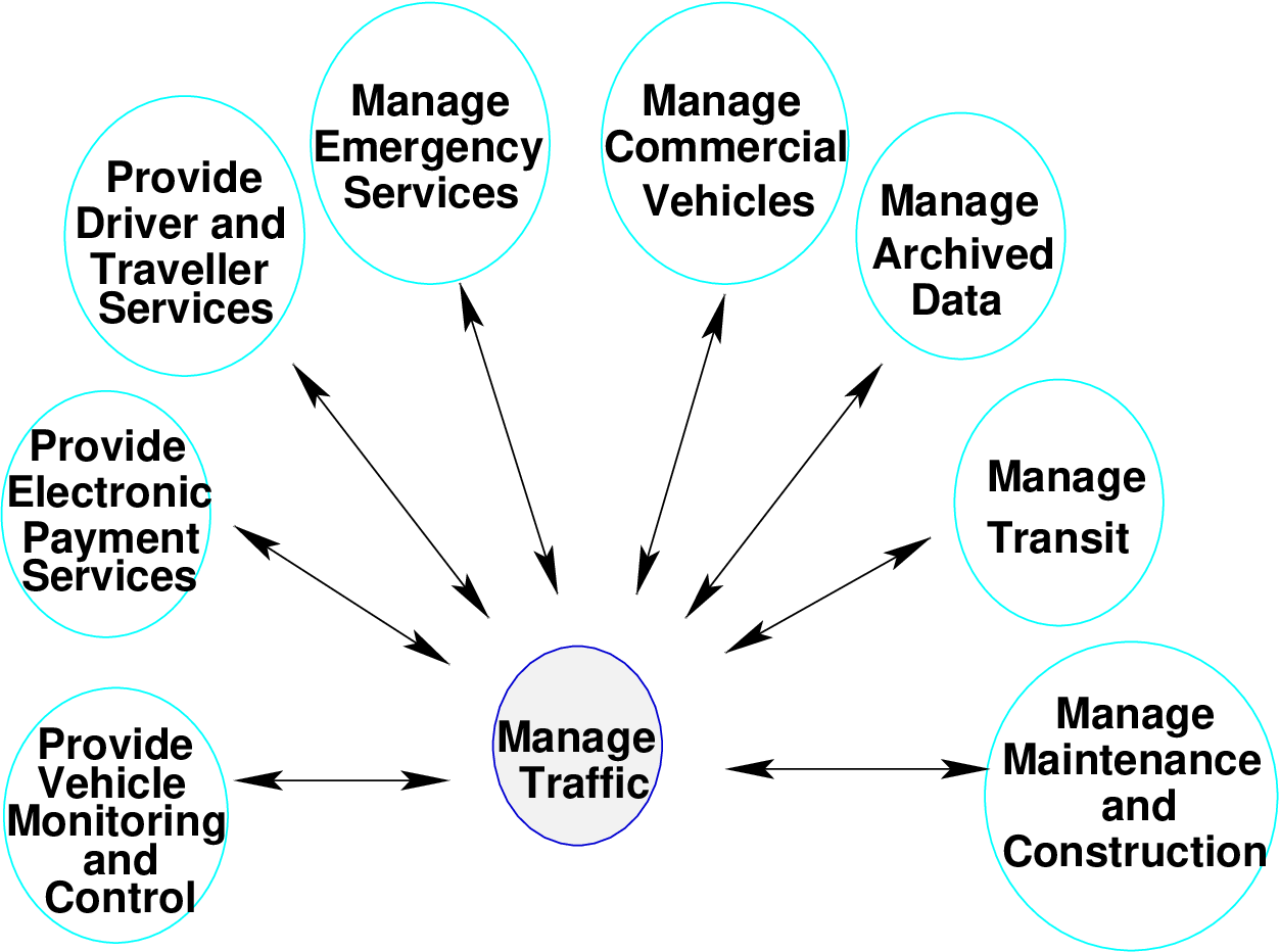
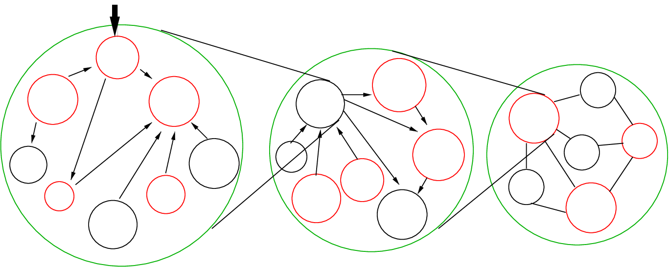
To accomplish user service requirements many functions or processes are needed. The logical architecture defines a set of functions (or processes) and information flows (or data flows) that respond to the user service requirements. It describes the lower end interaction of different components of ITS. Processes and data flows are grouped to form a particular functions. These are represented graphically by data flow diagrams (DFDs). Fig. 9 shows the interaction of Manage Traffic process with other processes. Each process is broken down into more sub processes. The sub process is further broken into sub process which are called process specifications (P-specs) lowest level. These p specs are required to be performed to fulfill user services requirements. Fig. 10 shows process decomposition into process specifications.
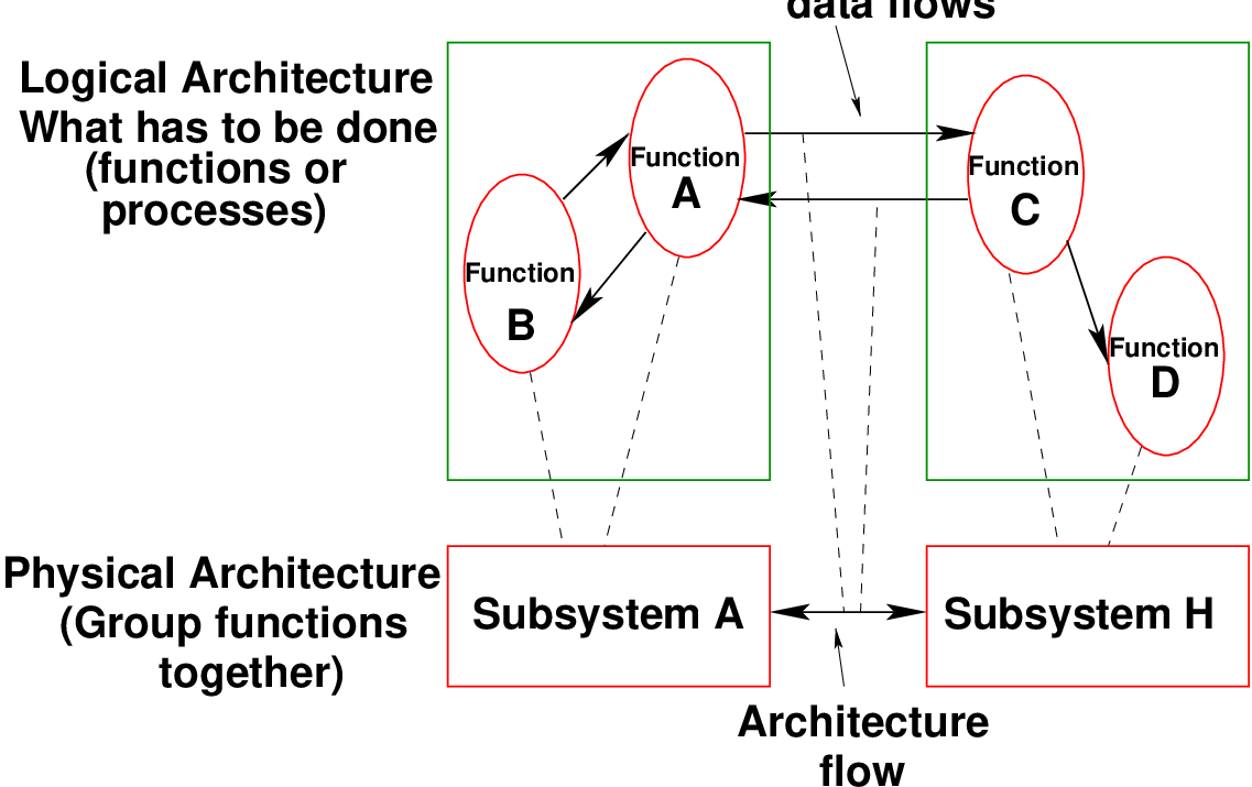
The functions from logical architecture that serve the same need are grouped into sub systems. With these subsystems a physical entity is developed to deliver functions. The data flow of logical architecture are also combined to define interface between subsystems. Fig. 11 shows the functions A and B of logical architecture assigned to subsystem A in physical architecture. Both the architecture forms the core of ITS.
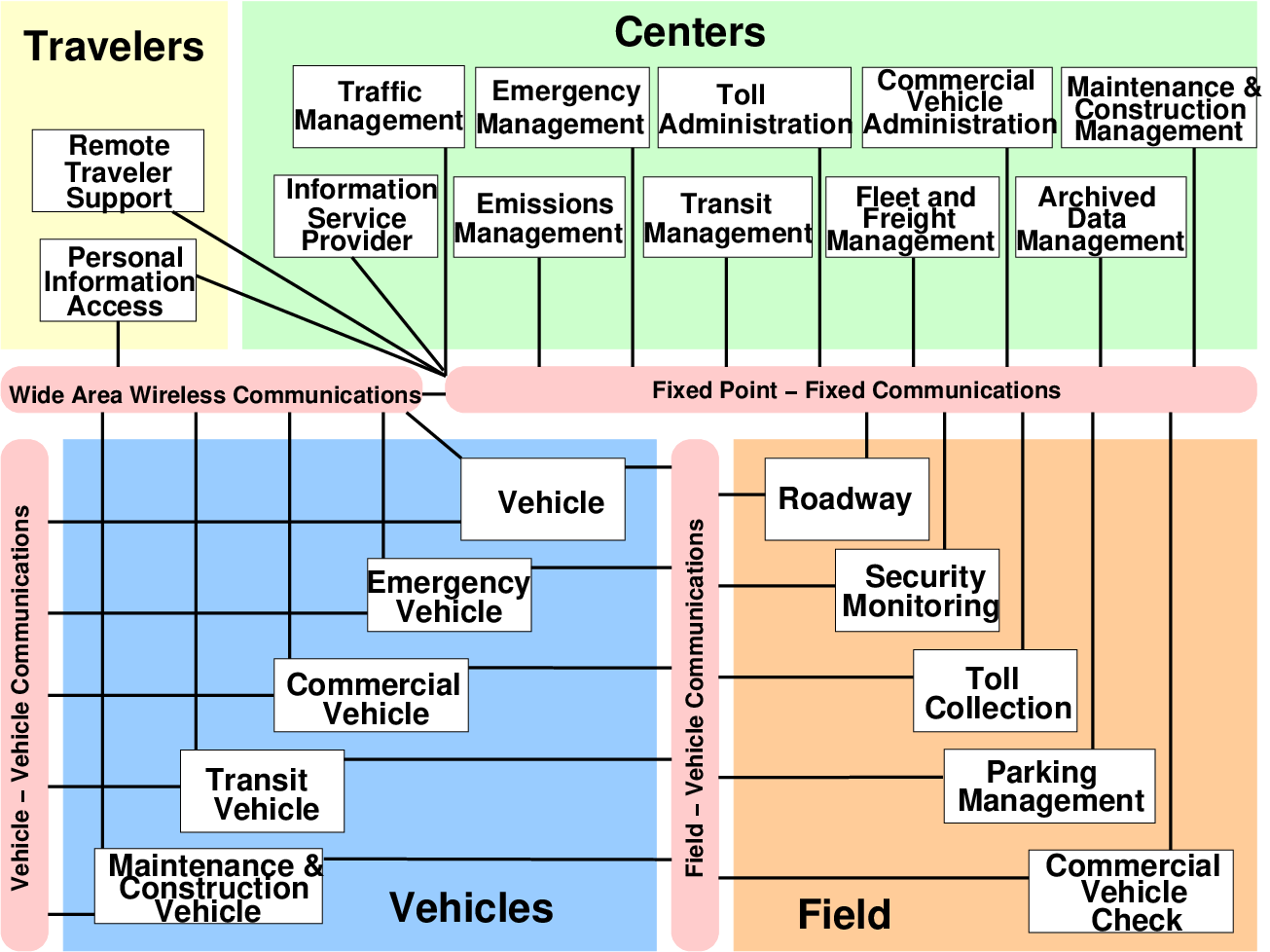
The physical architecture of ITS defines the physical subsystems and architectural flows based on the logical architecture. The 22 subsystems are broadly classified in four groups as centers, field, vehicle, and travelers. Fig. 12 shows the subsystems and communications that comprise the national physical architecture. The subsystem represent aggregation of functions that serve the same transportation need and closely correspond to physical elements of transportation management system.
Vehicle group consists of five different types of vehicles. The traveler group represents different ways a traveler can access information on the status of the transportation system. There are four different types of communication systems.
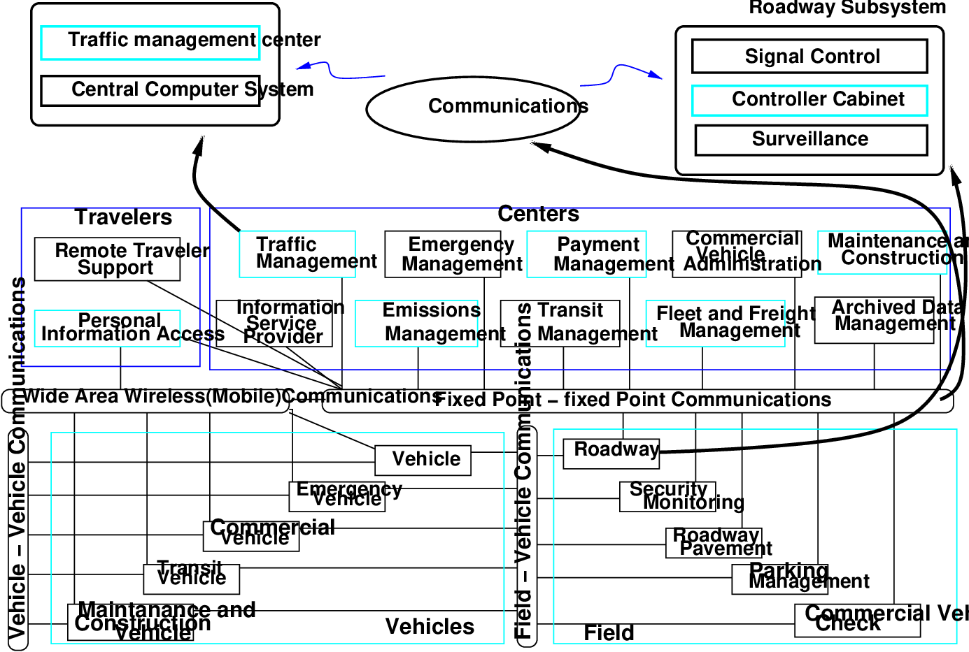
Through the communication systems all the subsystems are interconnected and transfer the required data. Fig. 13 shows the communication between traffic management subsystem and the roadway subsystem. Traffic management subsystem is connected to communications which gets real time information of the transportation system through roadway subsystem which comprise of signal control, detectors, camera, VMS etc.
In order to provide more deployment oriented perspective to the ITS architecture an equipment package is developed. In this similar functions of a particular subsystem are grouped together and implemented by a package of hardware and software facilities. As an example Table. 2 shows the TMC signal control equipment package and its functional requirements.
| TMC Equipment package provides the capability for traffic managers to monitor |
| and manage the traffic flow at signalized intersections. It analyzes and reduces the |
| collected data from traffic surveillance equipment and implements control plans |
| for signalized intersections. |
| TMC signal control equipment package contains five P- specs: |
| (i) Traffic operation personnel traffic interface |
| (ii) Process traffic data |
| (iii) Select strategy |
| (iv) Determine indicator state for road management |
| (v) Output control data for roads |
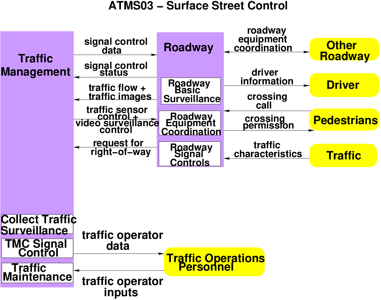
The market package defines a set of equipment packages that are required to work together to provide a given transportation service. Most market packages are made up of equipment packages from two or more subsystems. These are designed to address specific transportation problems and needs. Fig. 14 shows surface street control market package.
This package provide the central control and monitoring equipment, communication links and the signal control equipment that support local street control or arterial traffic management. The various signal control systems dynamically adjusted control plans and strategies based on current traffic conditions and priority requests.
ITS planning is to integrate ITS into the transportation planning process.
Transportation planning helps in shaping a well balanced transportation system that can meet future demands. Transportation planning is an iterative process which include problem identification, solution generation, analysis, evaluation and implementation. This can be integrated with ITS using computers, communication systems and software. As planning is normally made for long period, installing ITS facilities needs to be updated and one should ensure that the equipments and technologies are compatible for future improvement and expansion. The steps in traditional transportation planning are as follows:
ITS transportation planning process differs from the traditional transportation planning process. ITS has the unique capability to integrate different modes of transportation such as public auto, transit, and infra-structural elements through communications and control. The multi-modal integration potential provides a great opportunity for planning across modes. The comparison between ITS approach and conventional approach for solving various transportation problems are shown for few problems are shown in table. 3.
| Problem | Possible solutions | Conventional approach | ITS approach |
| Lack of | Provide user | Expand fixed route | Multi-modal pre trip and |
| mobility | friendly access to | transit and Para | en-route traveler |
| and | quality | transit service | information |
| accessibility | transportation | ||
| services | Radio and TV | Personalize public | |
| traffic reports | transportation | ||
| Enhance fare card | |||
| Traffic | Increase roadway | New roads | Advanced traffic |
| congestion | capacity | control, advanced | |
| Car pooling | vehicle systems | ||
| Reduce demand | |||
| Flex-time program | Real time ride matching | ||
| Personalized public | |||
| transport | |||
| Telecommuting | |||
| transportation pricing | |||
| Traffic | Improve safety | Improve roadway | Fully automated vehicle |
| accidents | geometry, sight | control system | |
| distance, traffic | |||
| signal | Automated warning | ||
| system | |||
| Grade separated | |||
| intersection | Driver condition on | ||
| monitoring | |||
| Driver training | |||
| Automated detection of | |||
| Street lighting | adverse weather | ||
| Emergency notification | |||
ITS architecture is a useful tool for integrating ITS technique into planning process. The ITS architecture defines the comprehensive set of data that should be shared by various agencies of transportation network. With the knowledge of what data must be exchanged, these agencies develop a common interest in cooperating planning efforts between all transportation projects.
ITS planning process follows a systems engineering approach to develop a deployment plan in descending order vision, goal, objectives, and functions. Table. 4 shows the ITS approach for achieving goal “enhance public safety”.
| Vision | Improvement of travelers safety by providing advance warning by
| |
implementing crash counter measures and by controlling to the security
| ||
| of the transportation facilities
| ||
| Goal | Enhance public safety
| |
| Objectives | Promote safety of transportation | Reduce crashes on freeways |
| facility | and streets | |
| Functions | # Monitoring of rest areas | # Implement crash counter |
| measures at high accident | ||
| # Provide public safety at park | locations | |
| and ride lots | ||
| # Implement work zone safety | ||
| # Coordinate emergency response | measures | |
| using appropriate agency | ||
| # Install traffic signs signals and | ||
| road marking | ||
| # Remove obstruction from the | ||
| incident scene | ||
Integrating ITS into transportation planning process require overcoming some obstacles and some changes in the business practices of many institutions. The major challenges in mainstreaming ITS into everyday operations of transportation agencies are:
Most public agencies are aware of the challenges in mainstreaming ITS into transportation planning process where ITS projects are part of traditional transportation programs on local or state level to achieve the best output from transportation investments.
This lecture introduces three important intelligent transportation system concepts such as: user services architecture planning. ITS user services includes concept on Travel and traffic management, Public transportation operations, Electronic payment, Commercial Vehicle operations, Advanced vehicle control and safety systems, Emergency management, Information management, and Maintenance and construction management A general ITS architecture and its national representation is then covered. The ITS planning discusses how to integrate ITS into transportation planning
I wish to thank several of my students and staff of NPTEL for their contribution in this lecture. Specially, I wish to thank my student Mr. Shekhar Babu for his assistance in developing the lecture note, and my staff Ms. Reeba in typesetting the materials. I also appreciate your constructive feedback which may be sent to tvm@civil.iitb.ac.in
Prof. Tom V. Mathew
Department of Civil Engineering
Indian Institute of Technology Bombay, India
_________________________________________________________________________
Thursday 28 September 2023 11:41:01 AM IST